Contact Beth Northrop
ejnorth123 AT juno.com
![]()
Harrogate Ripley Killinghall Area
Folktales, Roman Celtic and Other historic Sites
St Mungo's Well | Devil's Stone | Devil's Arrows OR Three Grey Hounds, Three Sisters
|
St Mungo's Well (Copgrove) (northeast of Ripley and Killinghall) submitted by rogerkread You may be viewing yesterday's version of this page |
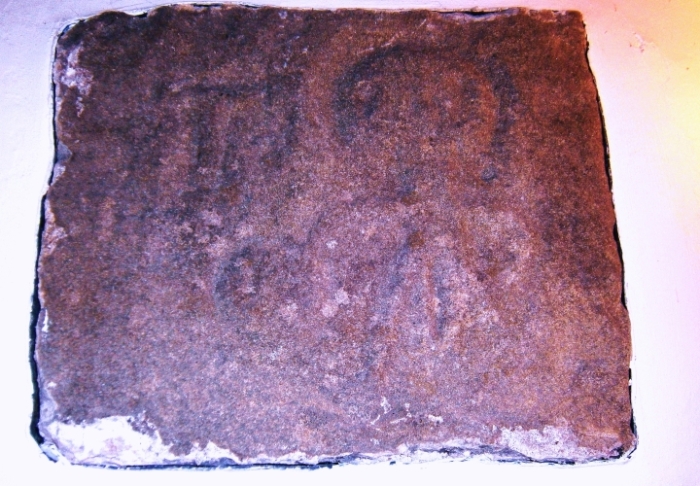
Copgrove Well The Copgrove Well by P. D. Hartley In 1922, Basil Blackwell of Oxford published privately a book by the Revd. Henry Dewsbury Alves Major B.D. entitled Memorials of Copgrove. The Revd. Major was a scholarly man who, after his incumbency as the Rector of the small church of St Michael from 1911 until his retirement in 1919 dedicated 'The Memorials' rather charmingly as follows: 'Admiral Sir Francis Bridgeman GCB, GCVO, Vice-Admiral of the United Kingdom of Great Britain and Ireland and of the Admiralty thereof and to Lady Bridgeman of Copgrove Hall, Lady of the Manors of Copgrove & Walkingham, and to the Parishioners of Copgrove, these memorials of their Parish with affection and respect I dedicate.' The book must have been produced at no small cost; everything about it is good, even to the careful choice of the typescript and the quality of the paper used in the printing. Small villages with an individual charm are often described as 'sleepy' and this description certainly applies to Copgrove. Lying in the rolling, morainic land between Knaresborough and the market town of Boroughbridge and on the western flanks of the Plain of York, it is dominated by The Hall, set on a low hill overlooking a large, reed-fringed lake, and by a thousand acres of wooded, game-filled land. The distant low roar of traffic on the modern Great North Road seems to add rather than to detract from the charm and solitude of the place. Little has happened in Copgrove since the legions marched away from nearby Isurium Brigantum, the important, fortified Romano-British town which lies some three miles to the north east. Today the village of Aldborough covers the site, for Isurium is many feet below, preserved in the silts of the River Ure. In 1309 Archbishop William de Greenfield of York passed by Copgrove, remarking derogatorily on the dilapidation at that time of the church; something was done, and parochial pride restored. But what of The Well - St Mungo's Well - what indeed of the Copgrove well? It can hardly have been by chance that in 1626 Dr Edmund Deane found it necessary, in his Spadacrene Anglia to blast off a broadside against this 'innefectual superstitious relique of Popery', for people were coming from far and wide to seek a cure for their ills in the miraculous waters of St Mungo's Well. Dr Deane may be said to have had a vested interest in curative waters issuing from the earth, for after all, such waters were known in the mountains of Bohemia, and in parts of France, and more importantly had recently been discovered at Starbeck on the outskirts of nearby Knaresborough and in adjoining Harrogate. Sulphur water, Chalybeate water, Magnesia water which stank abominably but under medical supervision (such as that of the good Doctor) purged the body of its humours, relieved aching joints, and cured or alleviated a variety of ills. But people being people, they still came to the clear waters of St Mungo's Well and immersed themselves, totally and uncomfortably, in the cold, pure, silently bubbling water in the stone cistern which even today stands on the lands which briefly, for such is the nature of life, belonged to the good Admiral. An entry in the Copgrove Parish Register gives a rather sad insight into the fact that St Mungo's holy water was more mystical than medical: 'A stranger Yt. came to Ye well was buried May 27 1710'. The question now arises as to how the well got its reputation for magical powers and how it came to be named after an obscure Celtic saint. There are five tenuous clues which, if they can be accepted point to a dark, indeed even a sinister history, going back far in time. The first three clues are geographical and all are within a radius or four miles from the well. They are the known site of Isurium Brigantum, the known presence of a 'roman road' which must have run close to the well and was probably on the site of an even earlier track, and three Standing Stones - Druid Stones, they have been called. The remaining clues consist of five coins found in the well precincts, and a carved stone of undeniable antiquity, now set in the north wall of Copgrove church. Four of the coins range over the reigns of William III to George III, but the fifth is a Bronze of the Emperor Hadrian. How did it get there, and why? In Roman times, the surrounding country was primeval forest of oak and ash. There remains the 'Devil's Stone' in the north wall of the church. Much eroded by time, it still clearly portrays the figure of a man. Hanging from his left hand is a roughly circular object and to his right is what has been described as a TAU cross; whatever the latter may have been designed to represent, it is certainly in the form of a letter T. Discussing Druidism, Prof. Lloyd Laing states tersely and somewhat dryly, 'skulls have a habit of being discovered without their skeletons in Romano-British wells'. And so a scenario is set. There is no surviving record of human remains ever having been recovered from St Mungo's Well, but a severed head and a sacrificial knife would describe the objects on the Devil's Stone far better than any alternative suggestions so far forthcoming. Then, when the Romans made their third and final push north of the Humber in the conquest of Britain, Isurium was already a populous, thriving Celtic Brigantian town and remained so throughout the occupation. Druidism would be established, and would certainly linger on. How did the Bronze find its way to the well? People both use and lose coins; they drop out of pockets, pouches and purses; sometimes they are thrown, confidently or privily as offerings to ambition, of propitiation or simply, hope. Was it an offering made secretly and perchance fearfully in the gloom of the forest, or was it simply - lost? Finally, to the matter of St Mungo and a dedication made to him in the Dark ages, far from his native land in the ancient, Celtic kingdom of Strathclyde. Bishop Kentigern (for 'Mungho' is a pseudonym meaning 'dearest one') was a reforming cleric in the days when much of Britain was pagan and even in the christianised parts, many held firmly to the Old Beliefs. Was there a dark power invested in the waters of the well which was so great that the Holy Man deemed it necessary to exorcise it himself? Certainly he was associated in some way with the ancient Minster of Ripon some eight miles away, where his pastoral staff, given him by St Columba, was revered as a relic in early mediaeval times. Did he really tread the ancient road now lost, through the forest, to the Druid's Well? On such things we may speculate, but the truth we may never know. http://people.bath.ac.uk/liskmj/living-spring/sourcearchive/fs4/fs4pdh1.htm |
Site Name: Devil's Stone (Copgrove) Alternative Name: Copgrove figure
I read with interest the article by P.D. Hartley on the Copgrove holy well (Source (First Series) issue 4) and decided, with my wife, and Edna Whelan, to visit the area and see both the well and the 'Devil's Stone'. The Holy Well (described as St Monagh's Well on the l:25 000 Ordnance Survey map - SE 3470 6378) is upon a public footpath which runs from Copgrove village (but is unsignposted) through the fields belonging to Copgrove Hall. The Well is, in fact, a very large chamber or cistern which has been let into the course of an underground stream. It is covered today by a padlocked wooden top, so a full inspection was not possible, but water could be heard flowing strongly through what sounded from the echo like a fairly empty receptacle. The chamber would, therefore, be useable again as a sacred healing bathing place if some future owner of the site wished to make it available. The site is enclosed by a wooden fence. The Well House, named on the O.S. map in the vicinity of the Holy Well, has presumably been destroyed as there is no trace of this structure left. The Devil's Stone is located on the north-east corner of the church of St Michael, Copgrove, about 500 yards south of the Well. The stone, with its interesting carving, used to be inside the church either against or within the north wall of the chancel but, during nineteenth century restoration, it was placed in its present external position where weathering will eventually erode it completely. The figure on the stone has been identified as, and certainly has all the features of, a Sheela-na-gig; the Celtic Goddess of Creation and Destruction. We took a very careful rubbing of the Copgrove carving which shows the figure holding her vagina open with her left hand, while in her right is an object which, as P.D. Hartley suggests, looks suspiciously like a head. What may be a ritual beheading axe appears to one side of the figure - though the official interpretation of this is a Tau Cross. In this Copgrove variant of the Sheela-na-gig, the Celtic beheading cult may be represented, symbolising more than simply the return of all life to the Otherworld womb of the Universal Mother; one aspect of the figure could be that the head is about to be thrust back inside the vagina, from which its life had originally emerged. There may be an interesting relationship here with the Celtic custom of associating carved stone heads with holy wells - for instance at St Helen's Well, Eshton (see Source (First Series) issue 5) where the carved heads are under the water, or at the Well of the Heads at Invergarry, and elsewhere, where heads are part of the Well House architecture. This custom, possibly hinted at by the Copgrove carving, may depict the rite of the creation of a Guardian; the ritual beheading and the subsequent capturing of the spirit of the victim within the human energy field of the carved stone head, which is then placed at or within the well. This Guardian entity is thus held 'between the worlds' at the Otherworld 'gateway' of the sacred waters of the Goddess - the Holy Well. The placing of real human heads within the pillars or door posts of Gallic temples in southern France has been noted, and this custom may have been more widespread than archaeological evidence (quite inadequate in this context) would seem to imply. Alternatively, it may be that the object in the right hand of the figure is not a head but a cauldron. This possibility is echoed in the name of Copgrove itself; cupa = cup (Gaelic) - a chalice or Grail and symbol of regeneration, like the womb of the Great Mother, portrayed in the figure of the Sheela-na-gig. The cauldron also connects with the Copgrove Holy Well, which has evidently always been a large bath type of receptacle, presumably for total immersion of the body. This is, maintaining the Celtic link, a graphic representation of the cauldron of Ceridwen, perhaps itself originally a holy well of inspiration and regeneration - the water being the channel, or medium through which these Otherworld powers were expressed in physical creation. Dr Ellison, quoted by Reverend Major in Memorials of Copgrovestates that the sick had to be dipped five, seven or nine times in the holy well in June or July and that 'the officious women at the Well are active in rubbing their backs or their maimed parts'. The doctor's observation was made in 1700, so we have here a graphic example of the survival of ancient, Pagan, customs in post-Parliamentarian (but pre-Enclosure) England. The Celtic association with Sheela-na-gig figures obviously dates, at Copgrove, from the pre-Saxon period, and the Devil's Stone has been identified as Romano-British. A few place-names in the area retain Celtic influence, for example Branton Court, one mile south of Copgrove, and Copt Hewick near Ripon. And, of course, Aldborough - Isurium Brigantum - is only three miles away to the north-east. |
Site Name: Devil's Arrows Alternative Name: Three Grey Hounds, Three Sisters, Devils Arrows Strikingly tall stones |
| Site Name: All Saints (Kirby Hill) Country: England County: Yorkshire (North) Type: Ancient Cross Nearest Village: Kirby Hill Ancient Cross in Yorkshire (North) Three different 9-11th century cross fragments, and contemporary gravestone fragment, in All Saints', Kirby Hill |
| Site Name: St Swithin's Well (Copt Hewick) Country: England County: Yorkshire (North) Type: Holy Well or Sacred Spring Nearest Town: Ripon Nearest Village: Copt Hewick Map Ref: SE3413271336 Latitude: 54.136739N Longitude: 1.47909W Condition: 4 Ambience: 1 Access: 5 Accuracy: 4 Internal Links: External Links: St Swithin's Well (Copt Hewick) submitted by KiwiBetsy 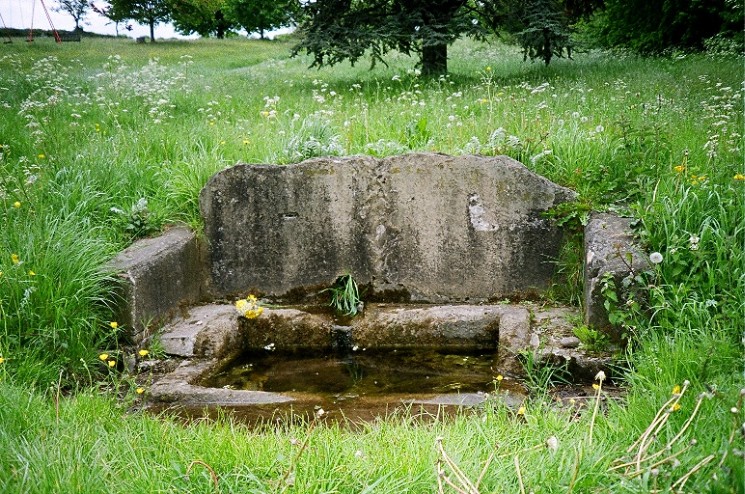 St Swithin’s Well is to be found on the village green at the eastern end of Copt Hewick on the right just past the Holy Innocents Church. St Swithin’s Well is to be found on the village green at the eastern end of Copt Hewick on the right just past the Holy Innocents Church.The well is dedicated to St Swithin who became Bishop of Winchester in 862AD. He must have passed this way at some stage, maybe on his way to visit St Wilfrid in nearby Ripon. When we visited in May 2003 the well was sitting lonely and unloved in the long grass. We traded it’s accumulated rubbish for a bunch of wildflowers and hope that we started a trend. |
| Site Name: Cana Henge Country: England County: Yorkshire (North) Type: Henge |
| Site Name: Copt Hewick Cursus Country: England County: Yorkshire (North) Type: Cursus Nearest Town: Ripon Nearest Village: Copt Hewick |
| Site Name: Hutton Moor Country: England County: Yorkshire (North) Type: Henge |
| Site Name: St Wilfrid's Holy Well Alternative Name: Wilfrid's Well Country: England County: Yorkshire (North) Type: Holy Well or Sacred Spring Nearest Town: Ripon Map Ref: SE309710 Latitude: 54.133923N Longitude: 1.528589W Condition: 4 Ambience: 4 Access: 5 Accuracy: 4 Internal Links: External Links: St Wilfrid's Holy Well submitted by Sunny100 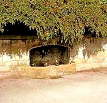 Holy Well or Sacred Spring in Yorkshire (North) Holy Well or Sacred Spring in Yorkshire (North)St Wilfrid's Holy Well at Ripon, N.Yorkshire, SE.309710. This well can be found to the W of Ripon Cathedral at the side of Skellbank Road. It is a medieval structure with a square stone chamber embedded into a wall - the top is curved inwards to the centre. At the back of the well a spout allows the water to gush down into a stone tank. This is usually half to three-quarters full, but at certain times there is hardly any water to be seen. St Wilfrid's Well was a place of pilgrimage for those coming to Ripon Cathedral/Minster - where the crypt contained some of the saint's relics. Wilfrid was born in 633 AD and became an influential [Roman] churchman in the north of England, founding a monastery at Ripon sometime between 655-660 AD. In 669 AD he became bishop of York. St Wilfrid died at Oundle, Northamptonshire, 709AD. The cult of St Wilfrid has remained strong at Ripon throughout the centuries, and his holy well has always been a much visited place of pilgrimage, in the hope that the saint might bestow a miracle of healing. |
| Site Name: Maiden's Bower (Asenby) Country: England County: Yorkshire (North) Type: Turf Maze Nearest Town: Ripon Nearest Village: Asenby Map Ref: SE409750 Latitude: 54.169174N Longitude: 1.375013W Condition: 2 Ambience: 4 Access: 2 Accuracy: 4 Internal Links: External Links: Maiden's Bower (Asenby) submitted by rogerkread Just beyond the village on a supposed motte and bailey site called significantly Maiden's Bower (a common name for sites with turf labyrinths and such I have named the site this although I am unsure if this is the name), is the remains of one of England's forgotten turf mazes. It measures 27 metres across with a 330 metre path long and beneath the overgrown mound a Chartres design similar to Breamore is some how preserved. It was last in good condition according to Allcroft (1908) in his Earthworks of England within living memory of that date as he states: ‘there are persons yet alive who have trodden it on many a summer’s evening and kneeling down at the centre have listened to hear the fairies singing’ . It can be reached by a footpath behind the Crab and Lobster Inn and affords good views as well. |
| Site Name: Nunwick Henge Country: England County: Yorkshire (North) Type: Henge |
| Site Name: Robin Hood's Well ( Yorkshire) Country: England County: Yorkshire (North) Type: Holy Well or Sacred Spring Map Ref: SE2767868295 Landranger Map Number: 99 Latitude: 54.109795N Longitude: 1.578145W Condition: 4 Ambience: 4 Access: 4 Accuracy: 5 Internal Links: External Links: Robin Hood's Well ( Yorkshire) submitted by HOLYWELL 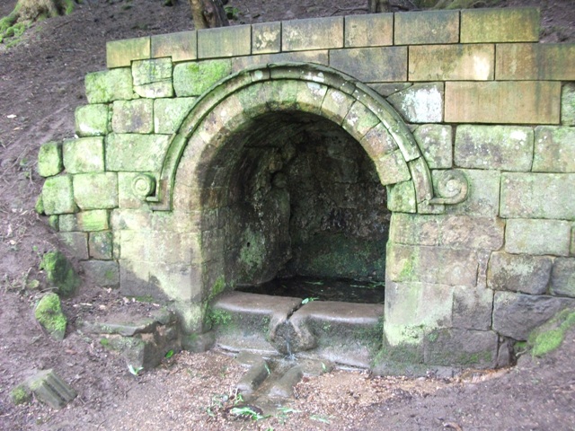 Possible Holy Well in North Yorkshire. A Victorian fancy or pagan site? Robert James Culverwell in his "The Enjoyment of Life; or Health, Recreation and Rational use of Time, 1850" notes: Yet for awhile let gay fancy beguile us with merry visions of the past. On this glade, the Curtal Friar of Fountains encountered Robin Hood, whom at length he threw into the Skell and, afterwards, fought to his heart's content. Possible Holy Well in North Yorkshire. A Victorian fancy or pagan site? Robert James Culverwell in his "The Enjoyment of Life; or Health, Recreation and Rational use of Time, 1850" notes: Yet for awhile let gay fancy beguile us with merry visions of the past. On this glade, the Curtal Friar of Fountains encountered Robin Hood, whom at length he threw into the Skell and, afterwards, fought to his heart's content. Then whistled out so many of his good ban dogs; but Little John let his arrows fly among them that "the Friar that had kept Fountain-dale seven long years and more" was brought to his sense in a trice. Presently we shall be seduced to halt at a shady knoll; and while reclining by the crystal well that still bears the outlaw's name, may pleasurably recall the rude romaunt that lingers in each youthful mind. Tradition points to a large bow and arrow, graven in the north east angle of the Lady Chapel, as a record of this dire affray. They bear no affinity to those symbols used by masons, but have, I fancy, induced the report mentioned by Ritson, that Robin's bow and arrows were preserved at Fountains Abbey. A delightful site which has improved in the last few years and now has the water running from it. |
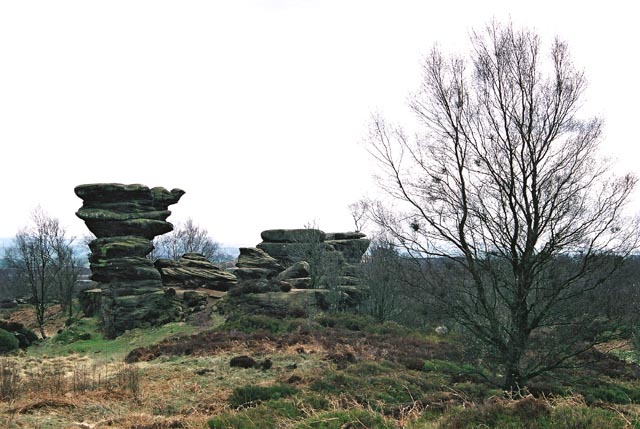
Site Name: Brimham Rocks Brimham Rocks submitted by andy_h |
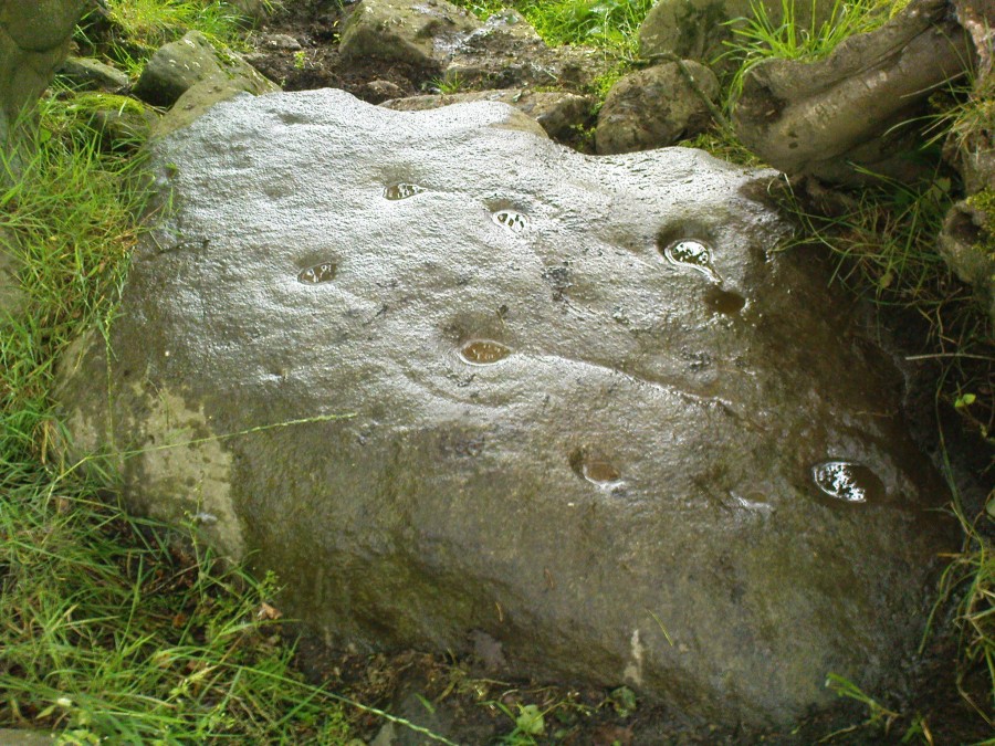
Site Name: Brimham Rocks Rock Art Country: England Cup and Ring marks / Rock Art in Yorkshire (North) |
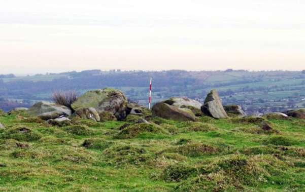
Site Name: Hartwith Moor Standing Stone in North Yorkshire |
Site Name: Fertility Stone (CR-638) Fertility Stone (CR-638) submitted by brigantia |
Site Name: Dacre Top Dacre Top submitted by GillianHovell |
| Site Name: Rocking Moor Country: England County: Yorkshire (North) Type: Rock Art Nearest Town: Otley Nearest Village: West End Map Ref: SE1183558009 Latitude: 54.017955N Longitude: 1.820867W Condition: no data Ambience: no data Access: no data Accuracy: 5 Be the first person to rate this site - see the 'Contribute!' box in the right hand menu. Internal Links: External Links: Rocking Moor submitted by QDanT 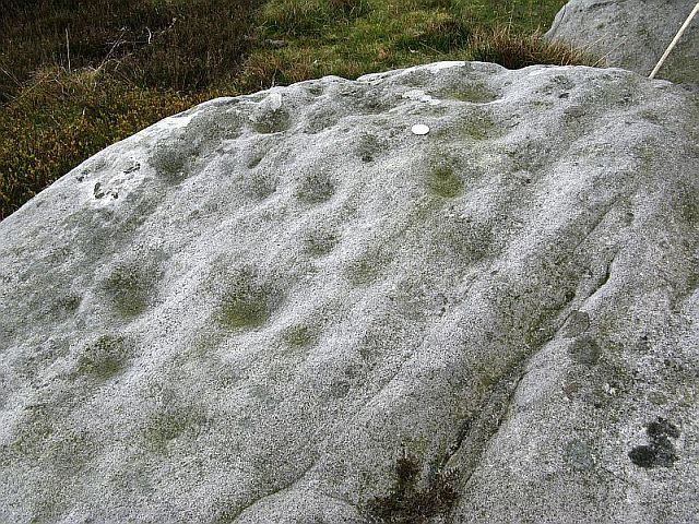 Cup and Ring marks / Rock Art in Yorkshire (North) Cup and Ring marks / Rock Art in Yorkshire (North)4 carvings situated close to the Raven Stones rock outcrop on Rocking Moor. Grid references for the carvings: SE118405802 - 22+ cups SE118405802 - 3 cups on NE lower level SE119305808 - 2 cup like basin (could be natural) SE119305810 - numerous cups & possible groove (could be natural) |
| Site Name: The Dovestones Country: England County: Yorkshire (North) Type: Stone Circle Nearest Town: Ilkley Nearest Village: Blubberhouses Map Ref: SE138554 Landranger Map Number: 104 Latitude: 53.994458N Longitude: 1.790996W Condition: 3 Ambience: 4 Access: 3 Accuracy: no data Internal Links: External Links: The Dovestones submitted by DavidRaven At the end of a long days hiking in the South Pennines, myself and a couple of mates decided to make the detour to search out the circle on our way home. Fatigue and a distinct lack of a nearby hostelry made our wanderings swift, and after walking all round Raven's Peak, we decided to try the other side of the ravine. Peering into the valley we eventually saw a single monolith, just visible in the light of dusk. Climbing down we noted the remains of low rubble walls just to the east of the stone. Signs of an ancient settlement? The circle itself is very small, barely eight feet in diameter if my memory serves. I found out after the trip that Mr. Holmes thought it formed a figure of '8', but I never noticed. I'll have another look in the near future. The modern Ordnance Survey map doesn't show any sign of the circle (no surprise!), but when I checked out the 1854 map, it clearly had the words 'Dovestones' right where I reckoned the circle to be. Appropriately, the 'Dovestones' are on the opposite side of the valley from the popular landmark; 'Raven's Peak'. If you're up in that neck of the woods, check it out! See what you think... Grid ref SE 138 554 |
| Site Name: Long Stoop Country: England County: Yorkshire (North) Type: Standing Stones Nearest Town: Harrogate Nearest Village: Kettlesing Map Ref: SE209552 Latitude: 53.992423N Longitude: 1.682713W Condition: 4 Ambience: 3 Access: 3 Accuracy: 4 Internal Links: External Links: Long Stoop submitted by rogerkread Something of a mystery, little seems to be known about this stone which is named in Gothic script on Ordnance Survey maps. It lies at the corner of a wood just off a public footpath. As the photographs show one face possesses a deeply incised cross. A pair of 'long stoops' is shown at approximately this location on John Ogilby's 1675 map of the York to Lancaster road. However if this stoop is indeed one of those then it must have been moved as it lies about half a mile from the current A59 - as this is a Roman road just here it is almost certain to be in the same location as it was in the C17th! Probably a waymark of some sort and almost certainly not a Christianised menhir - but interesting and so perhaps worthy of inclusion on Megalithic. |
Calverley Site Name: St Wilfrid (Calverley) |
